Amharcóir Pleanála Teanga GIS / Language Planning Viewer GIS
About the Author/Organisation
The Department of Tourism, Culture, Arts, Gaeltacht, Sport and Media works across tourism, culture, language, sports, media and broadcasting to promote economic growth, social well-being and Irish identity.
About the Project
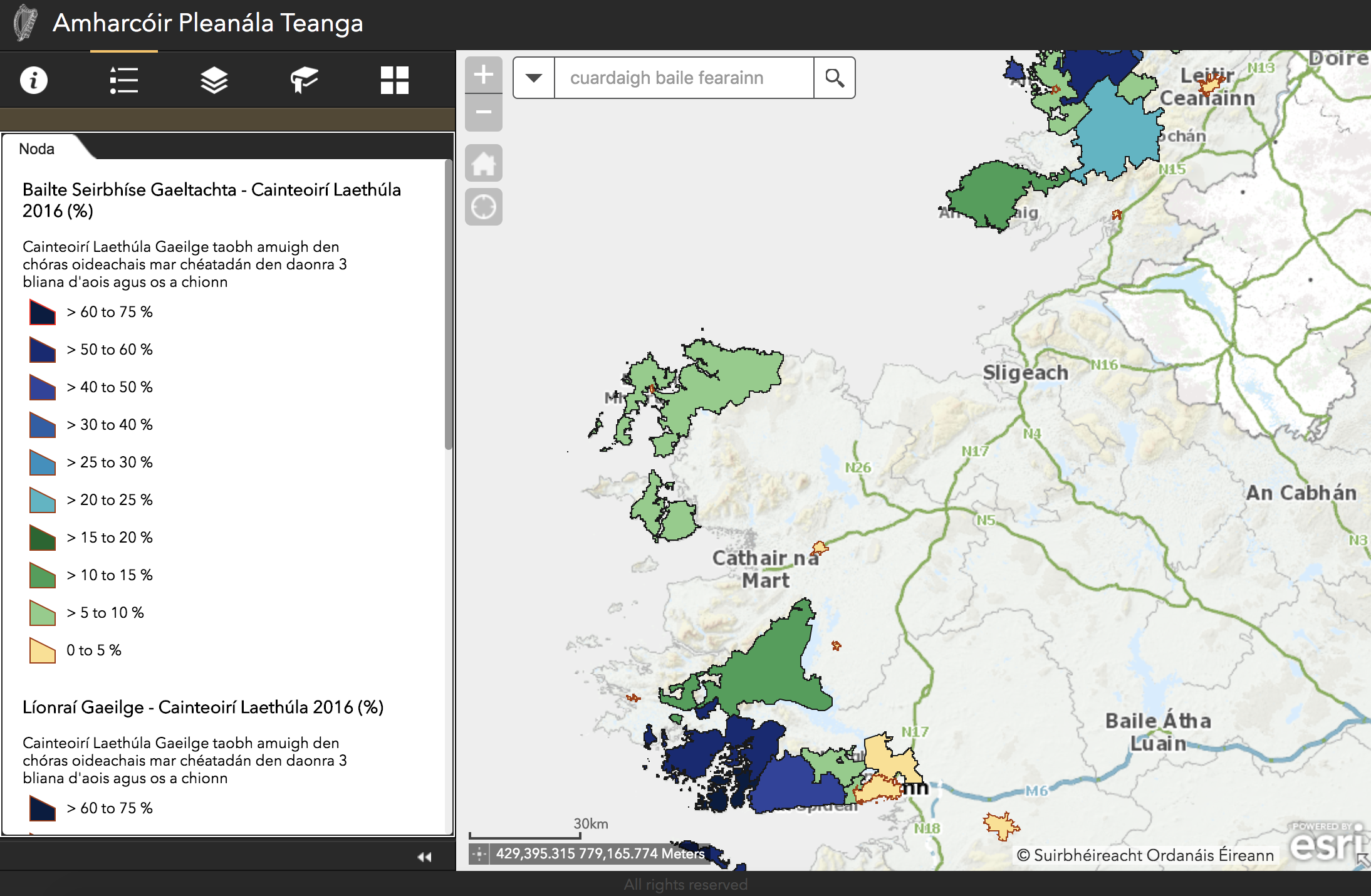
The Geographic Information System (GIS) is a facility which provides information, using a map viewer, in relation to the use of Irish as it relates to:
- the definition of Gaeltacht Language Planning Areas;
- towns which may be recognised as Irish Language Service Towns under the language planning process; and
- the use of Irish in the Irish Language Networks recognised under the process.
In the new version of the map viewer, information is provided - in collaboration with the CSO - according to Gaeltacht language planning areas as they relate to the results of the 2011 and 2016 Censuses as well as details on the use of Irish in towns which might be recognised under the process as Gaeltacht Service Towns, together with details on the use of Irish in the Irish Language Networks recognised under the process.
In addition to details relating to the use of Irish in these areas, information is also provided, in collaboration with the Department of Education and Skills and the Department of Children and Youth Affairs respectively, on the location and roles of primary and post-primary schools for the 2016/17 school year, as well as details pertaining to the early education sector in the Gaeltacht.
Why it's a Showcase
The information was gathered from the Ordnance Survey Ireland (OSi) and the Central Statistics Office (CSO) Census 2016 Open Data site.(http://census2016.geohive.ie). The project makes data on the use of Irish in various regions, Gaeltacht areas, and educational institutions readily available. This transparency fosters public understanding and engagement with Irish language initiatives. The data can be used to analyse trends, identify areas needing support, and develop targeted strategies to promote the use of Irish.
Impact of the Showcase
Open access to this data empowers researchers to study language use patterns and language revitalisation efforts. Making this data accessible fosters public awareness about the status of the Irish language, potentially leading to increased engagement with the language and its preservation.
Maidir leis an Údar/Eagraíocht
Bíonn an Roinn Turasóireachta, Cultúir, Ealaíon, Gaeltachta, Spóirt agus Meán ag obair ar fud na turasóireachta, cultúir, teanga, spórt, na meán agus craoltóireachta le fás eacnamaíochta, folláine shóisialta agus féiniúlacht na hÉireann a chur chun cinn.
Maidir leis an Togra
Is áis é an Córas Faisnéise Geografaí (GIS) ina gcuirtear eolas ar fáil, ag úsáid amharcóir mapa, maidir le húsáid na Gaeilge mar a bhaineann sé:
- leis na Limistéir Pleanála Teanga Ghaeltachta;
- le bailte a d'fhéadfadh a bheith aitheanta mar Bhailte Seirbhíse Ghaeltachta faoin bpróiseas pleanála teanga; agus
- le húsáid na Gaeilge sna Líonraí Gaeilge atá aitheanta faoin bpróiseas.
San eagrán nua den amharcóir mapa, tá eolas curtha ar fáil - i gcomhar leis an bPríomh-Oifig Staidrimh - ar bhonn limistéar pleanála teanga Gaeltachta mar a bhaineann sé le torthaí Dhaonáirimh 2011 agus 2016 chomh maith le sonraí maidir le húsáid na Gaeilge sna bailte a d'fhéadfadh a bheith aitheanta faoin bpróiseas mar bhailte seirbhíse Gaeltachta, in éindí le sonraí faoi úsáid na Gaeilge sna Líonraí Gaeilge atá aitheanta faoin bpróiseas.
Chomh maith le sonraí maidir le húsáid na Gaeilge sna ceantair seo, cuirtear eolas i láthair chomh maith, i gcomhar leis an Roinn Oideachais agus Scileanna agus leis an Roinn Leanaí agus Gnóthaí Óige faoi seach, maidir le suíomhanna agus rollú bunscoileanna agus iar-bhunscoileanna i leith na scoilbhliana 2016/17, chomh maith le sonraí faoin earnáil luathoideachais sa Ghaeltacht.
Cad a Dhéanann Taispeántas de
Fuarthas an fhaisnéis ó Shuirbhéireacht Ordanáis Éireann (OSi) agus ón bPríomh-Oifig Staidrimh (CSO) trí Shuíomh Sonraí Oscailte Dhaonáireamh 2016 (http://census2016.geohive.ie). Déanann an togra sonraí a chur ar fáil go furasta a bhaineann le húsáid na Gaeilge i réimse de cheantair, ceantair Ghaeltachta, agus in institiúidí oideachais. Cothaíonn an trédhearcacht seo tuiscint agus rannpháirtíocht phoiblí le tograí Gaeilge. Is féidir úsáid a bhaint as na sonraí le hanailís a dhéanamh ar threochtaí, ceantair a shainaithint a bhfuil tacaíocht uathu, agus le straitéisí spriocdhírithe a fhorbairt le húsáid na Gaeilge a chur chun cinn.
Tionchar an Taispeántais
Cumasaíonn rochtain oscailte ar na sonraí seo taighdeoirí chun staidéar a dhéanamh ar phatrúin úsáide teanga agus ar iarrachtaí athneartaithe teanga. Trí na sonraí seo a chur ar fáil go furasta déantar tuiscint phoiblí a chothú maidir le stádas na Gaeilge, rud a d’fhéadfadh rannpháirtíocht leis an teanga agus caomhnú na teanga a mhéadú.
 Derilinx