Marine Spatial Planning
About the Author/Organisation
The Department of Housing, Local Government and Heritage.
About the Project
MarinePlan.ie is an interactive web map portal that serves as Ireland's...
1 Dataset
View Marine Spatial Planning

fáilte - Discover Ireland's hidden gems
About the Author/Organisation
fáilte was developed by Carl Murray - more of Carl's work can be found at https://carlmurray.design or...
1 Dataset
View fáilte - Discover Ireland's hidden gems
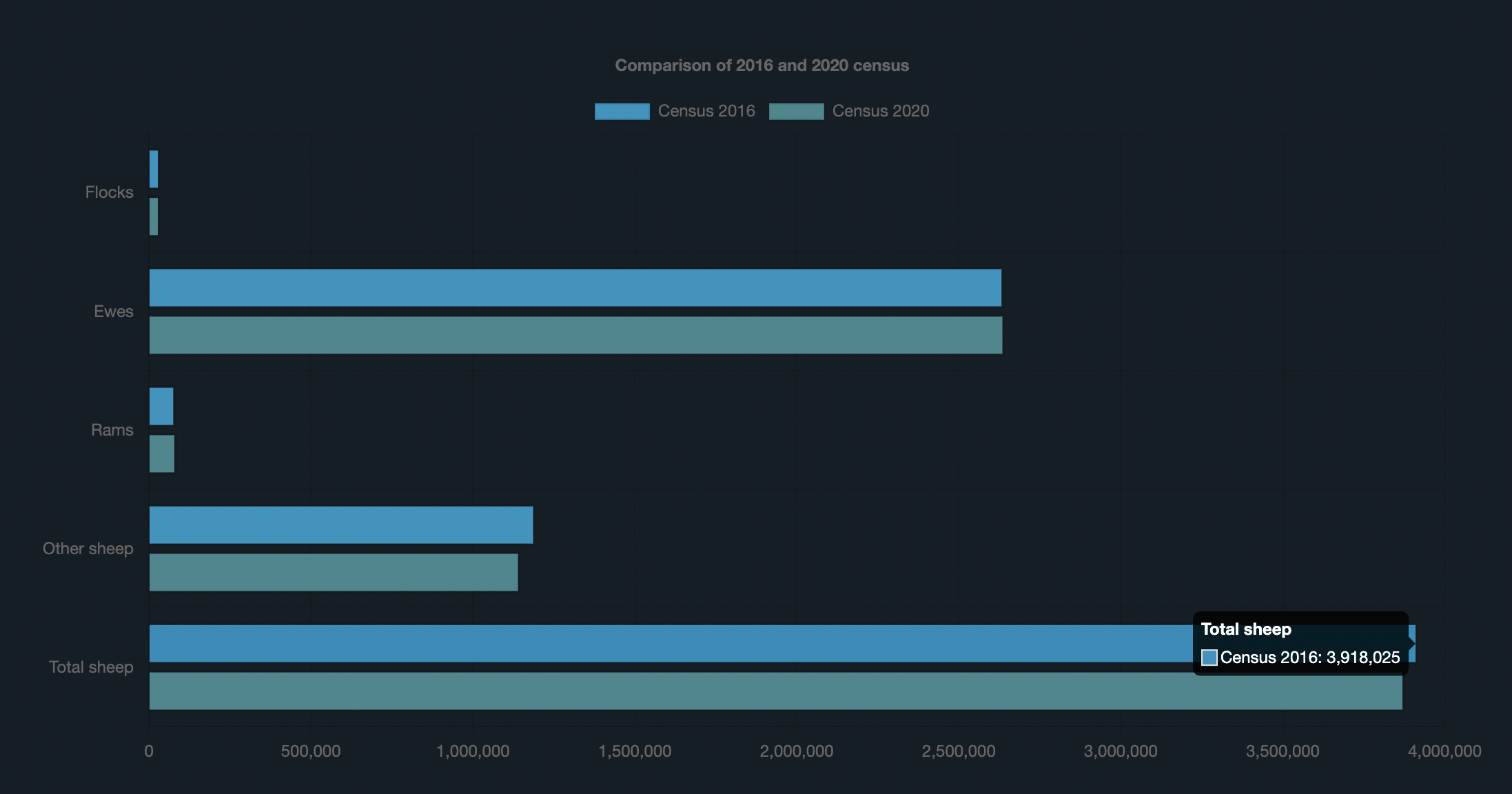
Irish Sheep Census
About the Author/Organisation
This app was created by Software Engineer Brian Douglas. See more of his work at
2 Datasets
View Irish Sheep Census

An easy command line tool for LUAS users
About the Author/Organisation
Created by Anderson Goulart.
About the Project
This is a command line (CLI) tool that helps LUAS users to access the Irish Transport information...
1 Dataset
View An easy command line tool for LUAS users
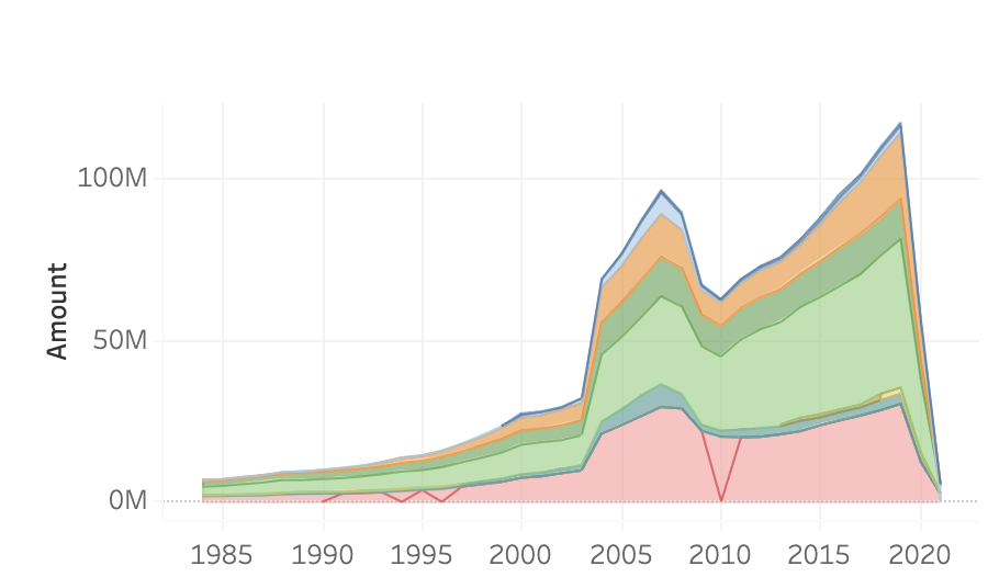
MONTHLY EXCHEQUER TAX RECEIPTS From 1984 To March 2021
About the Author/Organisation
Created by Tumasile Chilunga.
About the Project
Theses dashboard contains Open Data Tax Receipts- Monthly Exchequer Tax Receipts 1984 - 2021 March...
1 Dataset
View MONTHLY EXCHEQUER TAX RECEIPTS From 1984 To March 2021
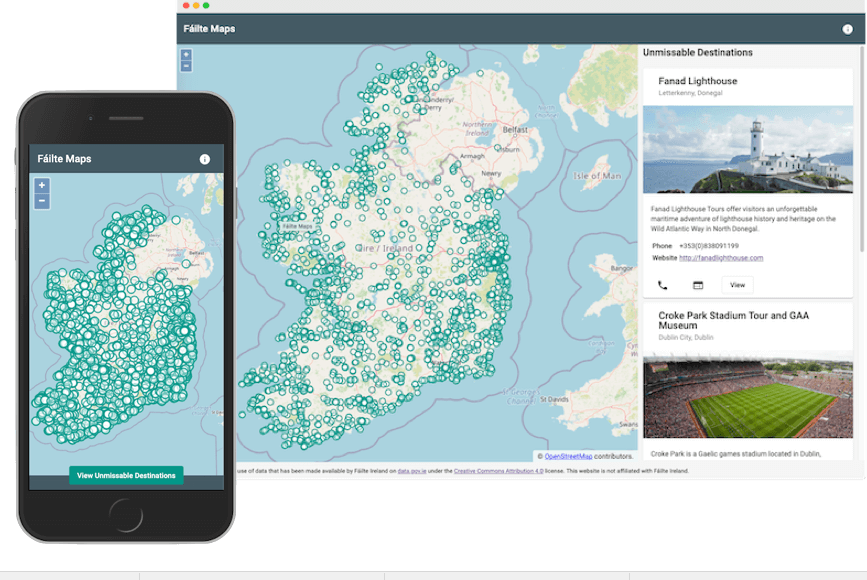
Failte Maps
About the Author/Organisation
Brian Douglas, Software Engineer. You can see more of his work by clicking this link.
About the Project...
1 Dataset
View Failte Maps

Local Infrastructure Housing Activation Fund (LIHAF) Story Map
About the Author/Organisation
The Department of Housing, Local Government and Heritage is responsible for overseeing the Local Infrastructure Housing Activation Fund (LIHAF)...
2 Datasets
View Local Infrastructure Housing Activation Fund (LIHAF) Story Map
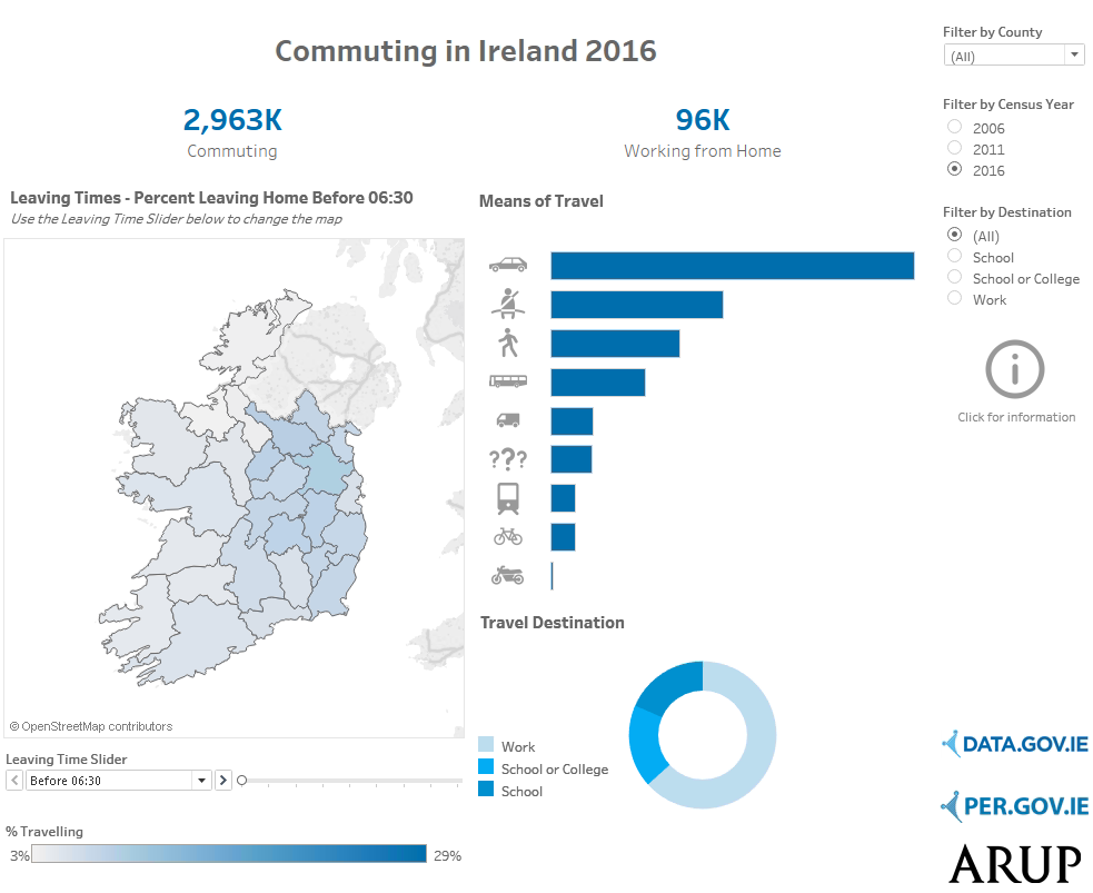
Commuting in Ireland
About the Author/Organisation
Arup Ireland, a leader in design and engineering, combines their expertise with data analysis to deliver valuable insights and project management...
2 Datasets
View Commuting in Ireland
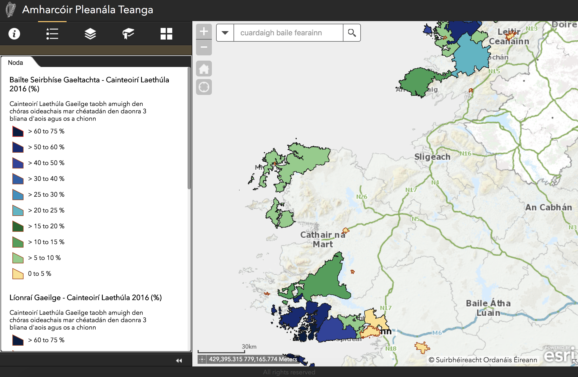
Amharcóir Pleanála Teanga GIS / Language Planning Viewer GIS
About the Author/Organisation
The Department of Tourism, Culture, Arts, Gaeltacht, Sport and Media works across tourism, culture, language, sports, media and broadcasting to...
4 Datasets
View Amharcóir Pleanála Teanga GIS / Language Planning Viewer GIS

Crimes at Garda Station Level and Pedestrian Footfall visualisations.
About the Author/Organisation
Cyril Connolly, Institute of Art, Design and Technology, Dun Laoghaire.
About the Project
The ‘Crimes at Garda Station Level and Pedestrian...
1 Dataset
View Crimes at Garda Station Level and Pedestrian Footfall visualisations.
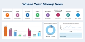
Where your money goes website
About the Author/Organisation
Office of the Government Chief Information Officer, Department of Public Expenditure, National Development Plan Delivery and Reform.
About the...
1 Dataset
View Where your money goes website
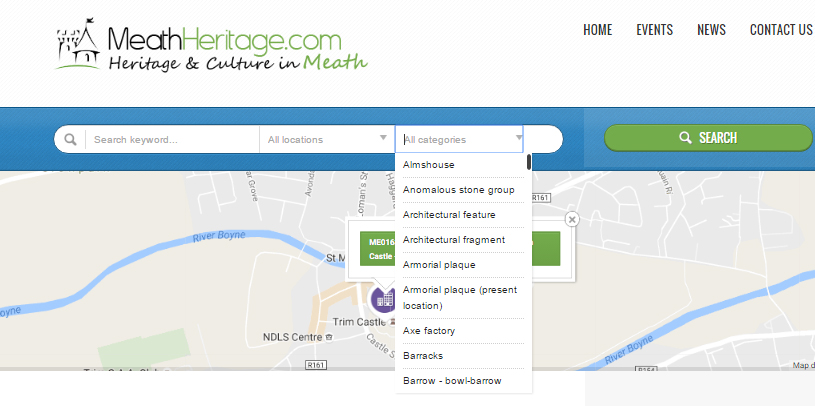
MeathHeritage.com
About the Author/Organisation
Alison Boland.
About the Project
MeathHeritage.com serves as a comprehensive resource for anyone interested in exploring the cultural heritage of...
1 Dataset
View MeathHeritage.com
HeritageMaps.ie
About the Author/Organisation
HeritageMaps.ie is a collaborative effort spearheaded by the Heritage Council of Ireland, working with local authorities, the National Biodiversity...
3 Datasets
View HeritageMaps.ie

ARIADNE and Ireland's cultural heritage data
About the Author/Organisation
The Discovery Programme, a Centre for Archaeology and Innovation in Ireland and ARIADNE. ARIADNE stands for Advanced Research Infrastructure for...
14 Datasets
View ARIADNE and Ireland's cultural heritage data
Ocean Energy Ireland Portal
About the organisation
The Ocean Energy Ireland brand has been developed by the Sustainable Energy Authority of Ireland (SEAI) and Marine Institute in accordance with the...
19 Datasets
View Ocean Energy Ireland Portal
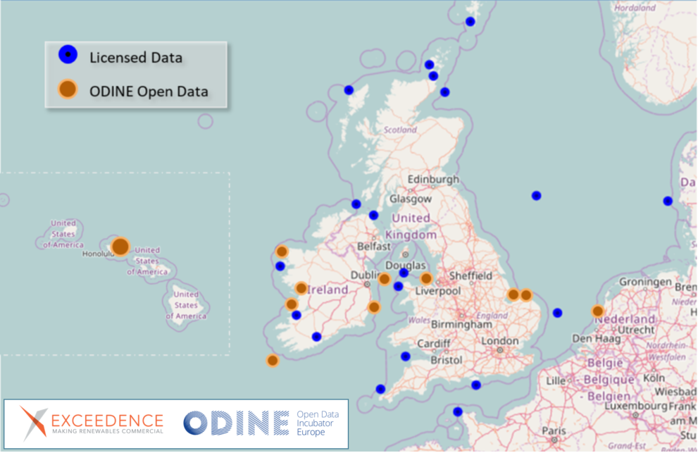
Monetising MetOcean Data - An Open Data Project
About the Author/Organisation
Exceedence is a company focused on empowering stakeholders in the renewable energy sector. They develop software tools that assist developers,...
14 Datasets
View Monetising MetOcean Data - An Open Data Project

Ireland's Marine Atlas
About the Author/Organisation
The Marine Institute is Ireland’s scientific agency responsible for supporting the sustainable development of the state’s maritime area and...
11 Datasets
View Ireland's Marine Atlas
GetThere.ie
About the Author/Organisation
GetThere.ie is a transportation information platform that aggregates coach and rail timetables and offers a lift-sharing service. They focus on...
11 Datasets
View GetThere.ie
 Derilinx